The Original Gay Porn Community - Free Gay Movies and Photos, Gay Porn Site Reviews and Adult Gay Forums

  • Welcome To Just Us Boys - The World's Largest Gay Message Board Community

    In order to comply with recent US Supreme Court rulings regarding adult content, we will be making changes in the future to require that you log into your account to view adult content on the site.
    If you do not have an account, please register.
    REGISTER HERE - 100% FREE / We Will Never Sell Your Info

    To register, turn off your VPN; you can re-enable the VPN after registration. You must maintain an active email address on your account: disposable email addresses cannot be used to register.

Op-Ed Needed: a new Voting Rights Act

Yeah, classical liberalism = libertarianism, no doubt. How can Democrats be "liberals" when they are proponents of illiberal economic policy and are split 50-50 on social issues? (Gay Marriage = liberal, Affirmative Action = illiberal).

Anyway, I am amazed by the US voting system. 6-7 hour wait times to cast your ballot in some places? Why do you tolerate that?

Why do you still vote Tuesdays? We vote on Sunday in Germany. Why don't you do that too? I know our situation is not wholly comparable, because of many (Christian) restrictions on working on Sunday, only 12% of all Germans work on Sunday, compared to 35% of Americans (warning, I used the first Google result for these numbers so they may not be accurate). But there are still fewer people working on Sunday in the US, why don't you change the day you vote to make it easier for all Americans to vote?

This change would be a cheap and easy way to improve your system. For more information you should read this excellent article of David Frum.

http://edition.cnn.com/2012/11/05/opinion/frum-election-chaos/index.html
 
Wonderful. We have something called Elections Canada (www.elections.ca) that you might want to look into. A non-partisan agency that conducts the entire national election the same way.

You pointed me that way before. I think it's totally the way to go -- but I'd add one item, for the U.S.: they should do redistricting as well, putting an end to gerrymandering.
 
If you've never known the pleasure:

http://en.wikipedia.org/wiki/Trombiculidae

attachment.php


And that doesn't even get into the fire ants.

I went hiking barefoot in Alabama and the folks there were horrified. But there are tricks:

1. Eat lots of onion, garlic, and oregano -- bugs don't like the aroma these make from your skin, and stay away.

2. Smear feet with a camphor-heavy infusion, and wipe that lightly all the way up to the waist. Let soak in for at least an hour.

3. Cover all skin, in or out of clothes, with a heavy oil -- tanning oil works.

4. No matter how much you may itch while hiking, do not scratch, as it will reduce your protection.
 
You pointed me that way before. I think it's totally the way to go -- but I'd add one item, for the U.S.: they should do redistricting as well, putting an end to gerrymandering.

That should be taken out of the hands of people. Feed the population and demographic information into a computer program, how many reps the state has, and have the program do the rest. No plans to realign districts in certain ways, no plans to take seats from the other party through redistricting, and no ridiculous maps that look like they were drawn by children.
 
Excellent article indeed -- thanks.

I'll add to my proposed new Voting Rights Act a federal requirement that elections be overseen by non-partisan commissions. The states could form those in whatever way they wanted.

We'll probably get a new voting rights act. SCOTUS has two cases dealing with the current one on the docket, and it could end up forcing congress to rewrite and update the act to modern standards.
 
That should be taken out of the hands of people. Feed the population and demographic information into a computer program, how many reps the state has, and have the program do the rest. No plans to realign districts in certain ways, no plans to take seats from the other party through redistricting, and no ridiculous maps that look like they were drawn by children.

Sure but who gets to write the program?
 
Honest elections are extremely easy to construct, and yet here we are. Honest districts are extremely easy to construct - as are computer programs, and yet here we are.

A machine is only as honest as the people who program it.
 
And yeah, talking to someone from Texas about gerrymandering is like talking to bees about honey - our gerrymandered map from 2010 was sooooo discriminatory it was actually declared illegal, didn't stop the SC from letting it be used in the last election.

Putting it in a machine and then pretending that somehow that is a guarantee is just foolish.
 
Well aren't you a debbie downer. Getting redistricting taken out of state legislature's hands and into objective means like a computer program would be as simple as passing a federal law requiring all states to use objective means. Such programs as I described above already exist, and states like Colorado use them. Iowa also uses an objective system that has been extremely effective. The Federal government does have the constitutional authority to end gerrymandering, and has exercised that authority before in the Voter's right act of 1965.
 
You pointed me that way before. I think it's totally the way to go -- but I'd add one item, for the U.S.: they should do redistricting as well, putting an end to gerrymandering.

Your country does one thing right that we need to adopt here: the size of our constituencies is adjusted based on census data, but the US applies fairly strict rules to make them all the same size. In Canada, they still trade on the old excuse that a Member of Parliament for a rural area somehow has a greater burden in reaching his citizens than an urban MP (despite the fact that even small towns in Canada have had electricity, telephones and fax machines for almost 8 years already). So rural ridings are allowed to be small, while urban ridings grow to ridiculous size, diluting the votes of the city dwellers.

I think Mandela had it right with "One person, one vote." And I have no problem granting greater travel allowances for an MP whose riding is larger than most countries. But the principle of strict parity in constituency size, as in the US, is sorely needed here because the disparities are disgraceful: a riding can include a number of voters 25% above or below the mathematical average, unless the boundary commission decides there is a good reason to swell or shrink the district even more, in which case anything goes.

So, for example two relatively rural/small city comparisons: The MP for Yorkton/Melville in Saskatchewan has 66 000 citizens to represent, while the MP for Peace River in Alberta has 138 000. There is nothing in the modern era to justify that discrepancy.

Apart from that where the US gets the numerical weight much better, yes, the gerrymandering in the US is a disgrace. But mis-weighted constituencies is another form of gerrymandering. Lots of MPs for rural conservatives. As few as possible for urban liberals.
 
And yeah, talking to someone from Texas about gerrymandering is like talking to bees about honey - our gerrymandered map from 2010 was sooooo discriminatory it was actually declared illegal, didn't stop the SC from letting it be used in the last election.

Putting it in a machine and then pretending that somehow that is a guarantee is just foolish.

Not foolish at all. Nothing is ever a guarantee, but starting from a position that is orders of magnitude more objective is definitely more desirable than starting where we are in several states.
 
But it isn't objective, it's just pushes the wrangling into arguments over who gets to program the machine. That's all, nothing more.

Computers in an of themselves say nothing and even if one draws a map, some human established the parameters. THAT human whomever they might be is the one who is either honest or not.
 
But it isn't objective, it's just pushes the wrangling into arguments over who gets to program the machine. That's all, nothing more.

But that's where you're mistaken. It IS objective so long as the list of requirements that the maps must be drawn with are clear. (as I mentioned above) Any issues with the programming, or any attempts to game it, would be immediately clear. (generally, the objective redistricting methods result in districts that are clear polygons with very few jagged edges or irregular shapes)
 
...It IS objective so long as the list of requirements that the maps must be drawn with are clear. (as I mentioned above) Any issues with the programming, or any attempts to game it, would be immediately clear. (generally, the objective redistricting methods result in districts that are clear polygons with very few jagged edges or irregular shapes)

Maps DRAWN BY HAND are objective so long as the list of requirements that the maps must be drawn with are clear.

The machine is just a tool. Not a magic box. You don't have to "game the machine," if you control the "list of requirements" which has the same problems "lists of requirements" in politics have always had.

ANY FOOL can spot a gerrymandered map on sight no matter how it was generated, and no one is trying to hide the fact they are doing it, the "list of requirements" is where you want to start if you want something to change, and once you have that, it doesn't matter how the map was generated.
 
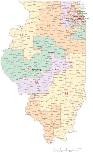
Good example: The 18th Congressional District, where I live, has obviously been drawn as a Republican district. Notably, especially, it has entirely excised the south side of Peoria, which is the area of the city which has the largest African-American population. Note that it has also cut out the entire city of Springfield, another Democratic island in a sea of red. I think that closer examination would also show me that it's excised Illinois State University (in Normal) and its immediate surroundings, another Democratic stronghold.

On the other hand, the 17th is drawn as a Democratic district, including Peoria's south side, and the Democratic "Quad Cities" area on its west-central side. Also note what they did with Rockford.

The 13th is also an OBVIOUS Democratic District, as it includes all of Springfield, the University of Illinois (Champaign-Urbana), and apparently Illinois State University as well...and Decatur, too.

The 12th surprised me, though - its southern part is indeed as "southern" as Alabama or Mississippi - while it also includes some deeply Democratic suburbs such as East St. Louis, Venice, etc. My guess is that the 12th is the token "swing district" to actually make it look like these Districts are drawn fairly, though I know nothing about election history there.

attachment.php


Some of the Chicago-area districts are even more blatant than these three.

Ironically where I live used to be a District which was drawn Democratic, more or less a C-shaped district which followed the Mississippi River for quite a ways (including the Quad Cities area), with its bottom extension going all the way over to the Democratic city of Decatur. It was called the 17th Congressional District at that time, and it was one of the most-Gerrymandered districts in the United States.
 

Attachments

  • IL 18th.jpg
    IL 18th.jpg
    70.4 KB · Views: 26
Maps DRAWN BY HAND are objective so long as the list of requirements that the maps must be drawn with are clear.

The machine is just a tool. Not a magic box. You don't have to "game the machine," if you control the "list of requirements" which has the same problems "lists of requirements" in politics have always had.

ANY FOOL can spot a gerrymandered map on sight no matter how it was generated, and no one is trying to hide the fact they are doing it, the "list of requirements" is where you want to start if you want something to change, and once you have that, it doesn't matter how the map was generated.

It does matter, because the computer drawn maps are less susceptible to bias and manipulation. If you give the duty of writing the software and mapping districts to an objective party, like Gallup or some similar organization, the possibility of the resulting maps being gerrymandered or affected on a political basis are near zero. We KNOW how objective the results are when you use these things because some states are already doing it. The federal government should make it mandatory, however.
 
Back
Top