jdcnow
Graphics Extraordinaire
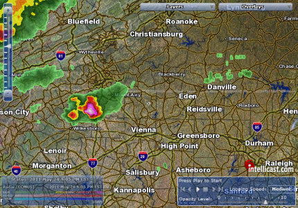
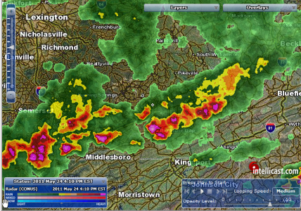
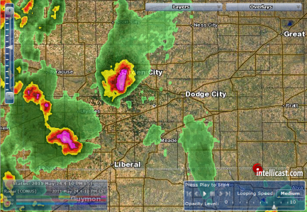
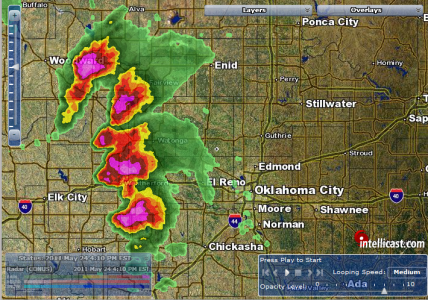
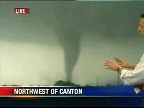
Well, good afternoon, all. Thankfully, I have some time to monitor the weather today. Looks like quite the nasty setup over northern Texas, most of Oklahoma, and Kansas, today. Of course, thoughts and well-wishes go out the good people of Joplin, MO as they pick up the pieces from the tornado, Sunday night.
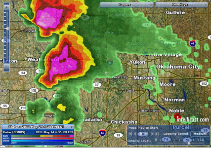
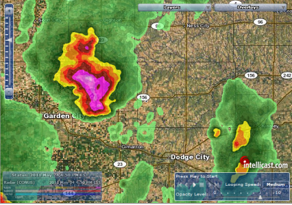
In the event that I should have to end early due to some unforseen reason, my weather-monitoring resources are Intellicast Interactive Doppler Radar, and the National Weather Service website for any warning statements.
Of course, if there's anyone affected by the weather this afternoon and tonight, let us know how it is where you are, and let us know that you and yours are OK, afterwards.
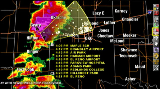
Quite the interesting Hazardous Weather Statment from the main Weather Service office in Norman, OK...
In the event that I should have to end early due to some unforseen reason, my weather-monitoring resources are Intellicast Interactive Doppler Radar, and the National Weather Service website for any warning statements.
Of course, if there's anyone affected by the weather this afternoon and tonight, let us know how it is where you are, and let us know that you and yours are OK, afterwards.
Quite the interesting Hazardous Weather Statment from the main Weather Service office in Norman, OK...
HAZARDOUS WEATHER OUTLOOK
NATIONAL WEATHER SERVICE NORMAN OK
1207 PM CDT TUE MAY 24 2011
THIS HAZARDOUS WEATHER OUTLOOK COVERS NORTHERN...WESTERN...
CENTRAL...AND SOUTHERN OKLAHOMA...AND WESTERN NORTH TEXAS.
.DAY ONE...THIS AFTERNOON AND TONIGHT...
THUNDERSTORM OUTLOOK...
THERE IS A HIGH RISK OF SEVERE THUNDERSTORMS ACROSS MOST OF OKLAHOMA
AND PARTS OF WESTERN NORTH TEXAS.
LOCATION...
THE HIGH RISK AREA COVERS LOCATIONS NEAR AND EAST OF A LINE
EXTENDING FROM ALVA...TO WEATHERFORD...TO WICHITA FALLS. THIS
INCLUDES THE CITIES OF ALVA...ENID...PONCA CITY...THE OKLAHOMA CITY
METRO...LAWTON...WICHITA FALLS...ARDMORE...ADA...AND DURANT.
WEST OF THE HIGH RISK...THERE IS STILL A RISK OF SEVERE STORMS... AS
FAR WEST AS WOODWARD...CLINTON...HOBART...FREDERICK...AND SEYMOUR.
TIMING...
THE MOST LIKELY TIME FOR SEVERE THUNDERSTORMS WILL BE FROM 3 PM
THROUGH MIDNIGHT.
IMPACTS...
THE POTENTIAL EXISTS FOR VIOLENT TORNADOES...PRIMARILY IN THE HIGH
RISK AREA. DESTRUCTIVE HAIL...POSSIBLY LARGER THAN BASEBALLS...AND
DAMAGING STRAIGHT LINE WIND WILL ALSO BE POSSIBLE IN THE RISK AREAS.
RECOMMENDED ACTIONS...
STORM SPOTTER GROUPS...EMERGENCY MANAGEMENT...AND ALL EMERGENCY
RESPONSE AGENCIES ARE ENCOURAGED TO MAINTAIN A HIGH STATE OF
READINESS THROUGHOUT THE DAY AND EVENING. THE PUBLIC SHOULD REVIEW
SEVERE WEATHER SAFETY PLANS AND BE PREPARED TO TAKE ACTION.
DISCUSSION...
A VERY STRONG UPPER-LEVEL STORM SYSTEM WILL MOVE QUICKLY OVER THE
REGION TODAY AND TONIGHT. WITH VERY MOIST AND UNSTABLE AIR AHEAD OF
THIS STORM...SIGNIFICANT SEVERE WEATHER IS EXPECTED. STORMS ARE
EXPECTED TO DEVELOP BY MID-AFTERNOON JUST WEST OF THE HIGH RISK
AREA...WITH STORM MOTIONS EASTERLY AT AROUND 30 MPH. WITH VERY
UNSTABLE CONDITIONS...AND STRONG WINDS AT ALL LEVELS OF THE
ATMOSPHERE...THE ENVIRONMENT WILL SUPPORT LONG-LIVED SUPERCELLS WITH
THE RISK FOR GIANT HAIL AND DAMAGING WINDS. TORNADOES WILL BE LIKELY
WITH THE MOST INTENSE STORMS...AND THE POTENTIAL WILL EXIST FOR ONE
OR MORE VIOLENT...LONG-TRACK TORNADOES IN THE HIGH RISK AREA.
THE RISK OF SEVERE WEATHER WILL CONTINUE WELL INTO THE NIGHT...BUT
SHOULD SHIFT INTO FAR EASTERN OKLAHOMA BY AROUND MIDNIGHT.
PROBABILITY TABLE...
VALID THROUGH 700 AM CDT WEDNESDAY MAY 25.
PROBABILITY OF THUNDERSTORMS OCCURRING IN THE
NWS NORMAN COUNTY WARNING AREA...100 PERCENT.
PROBABILITY OF SEVERE STORMS IF STORMS OCCUR...100 PERCENT.
") I'm glad you made it through, OK, Donny!
I'm glad you made it through, OK, Donny!  Was there very much damage?