The Original Gay Porn Community - Free Gay Movies and Photos, Gay Porn Site Reviews and Adult Gay Forums

  • Welcome To Just Us Boys - The World's Largest Gay Message Board Community

    In order to comply with recent US Supreme Court rulings regarding adult content, we will be making changes in the future to require that you log into your account to view adult content on the site.
    If you do not have an account, please register.
    REGISTER HERE - 100% FREE / We Will Never Sell Your Info

    To register, turn off your VPN; you can re-enable the VPN after registration. You must maintain an active email address on your account: disposable email addresses cannot be used to register.

  • Hi Guest - Did you know?
    Hot Topics is a Safe for Work (SFW) forum.

Severe Weather Update Thread (Tue Jan 29 2013)

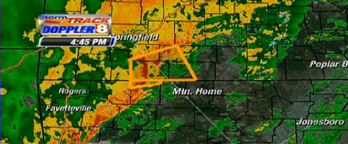
Wow, already getting this weather? I thought tornado season was in the Spring.

Tornados can happen anytime, anywhere, so long as the atmospheric conditions qualifications are met. Downtown Mobile, AL just got hit with a tornado last month, on Christmas Day.

 
Seeing storms refire in Southern MO...

BULLETIN - EAS ACTIVATION REQUESTED
TORNADO WARNING
NATIONAL WEATHER SERVICE SPRINGFIELD MO
412 PM CST TUE JAN 29 2013

THE NATIONAL WEATHER SERVICE IN SPRINGFIELD HAS ISSUED A

* TORNADO WARNING FOR...
STONE COUNTY IN SOUTHWEST MISSOURI...
WESTERN TANEY COUNTY IN SOUTHWEST MISSOURI...

* UNTIL 500 PM CST

* AT 408 PM CST...A SEVERE THUNDERSTORM CAPABLE OF PRODUCING A
TORNADO WAS LOCATED 12 MILES SOUTHWEST OF KIMBERLING CITY...AND
MOVING NORTHEAST AT 65 MPH.

HAZARD...DEVELOPING TORNADO AND QUARTER SIZE HAIL.

SOURCE...RADAR INDICATED ROTATION.

IMPACT...SIGNIFICANT HOUSE AND BUILDING DAMAGE POSSIBLE. MOBILE
HOMES COMPLETELY DESTROYED IF HIT. SOME TREES UPROOTED OR
SNAPPED. VEHICLES WILL LIKELY BE THROWN BY TORNADIC WINDS.

* LOCATIONS IMPACTED INCLUDE...
BRANSON WEST...BRANSON...CAPE FAIR...EDGEWATER BEACH...FORSYTH...
GALENA...HOLLISTER...INDIAN POINT...KIMBERLING CITY...KIRBYVILLE...
KISSEE MILLS...LAMPE...MERRIAM WOODS...OZARK BEACH...POWERSITE...
REEDS SPRING...RIDGEDALE...ROCKAWAY BEACH...SILVER DOLLAR CITY...
TABLE ROCK AND WALNUT SHADE.

THIS WARNING ALSO INCLUDES BULL SHOALS LAKE...TABLE ROCK LAKE AND
TABLE ROCK STATE PARK.

PRECAUTIONARY/PREPAREDNESS ACTIONS...

TAKE COVER NOW. MOVE TO AN INTERIOR ROOM ON THE LOWEST FLOOR OF A
STURDY BUILDING. AVOID WINDOWS. IF IN A MOBILE HOME...A VEHICLE OR
OUTDOORS...MOVE TO THE CLOSEST SUBSTANTIAL SHELTER AND PROTECT
YOURSELF FROM FLYING DEBRIS.
 
Reiterating the Tornado Warning in South Central MO until 5pm

SEVERE WEATHER STATEMENT
NATIONAL WEATHER SERVICE SPRINGFIELD MO
421 PM CST TUE JAN 29 2013

MOC209-213-292300-
/O.CON.KSGF.TO.W.0003.000000T0000Z-130129T2300Z/
STONE MO-TANEY MO-
421 PM CST TUE JAN 29 2013

...A TORNADO WARNING REMAINS IN EFFECT FOR WESTERN TANEY AND STONE
COUNTIES UNTIL 500 PM CST...

AT 418 PM CST...A SEVERE THUNDERSTORM CAPABLE OF PRODUCING A TORNADO
WAS LOCATED 10 MILES SOUTH OF KIMBERLING CITY...AND MOVING NORTHEAST
AT 60 MPH.

HAZARD...DEVELOPING TORNADO AND QUARTER SIZE HAIL.

SOURCE...RADAR INDICATED ROTATION.

IMPACT...SIGNIFICANT HOUSE AND BUILDING DAMAGE POSSIBLE. MOBILE HOMES
COMPLETELY DESTROYED IF HIT. SOME TREES UPROOTED OR SNAPPED.
VEHICLES WILL LIKELY BE THROWN BY TORNADIC WINDS.

LOCATIONS IMPACTED INCLUDE...
BRANSON WEST...BRANSON...CAPE FAIR...EDGEWATER BEACH...FORSYTH...
GALENA...HOLLISTER...INDIAN POINT...KIMBERLING CITY...KIRBYVILLE...
KISSEE MILLS...LAMPE...MERRIAM WOODS...OZARK BEACH...POWERSITE...
REEDS SPRING...RIDGEDALE...ROCKAWAY BEACH...SILVER DOLLAR CITY...
TABLE ROCK AND WALNUT SHADE.

THIS WARNING ALSO INCLUDES BULL SHOALS LAKE...TABLE ROCK LAKE AND
TABLE ROCK STATE PARK.

PRECAUTIONARY/PREPAREDNESS ACTIONS...

TAKE COVER NOW. MOVE TO AN INTERIOR ROOM ON THE LOWEST FLOOR OF A
STURDY BUILDING. AVOID WINDOWS. IF IN A MOBILE HOME...A VEHICLE OR
OUTDOORS...MOVE TO THE CLOSEST SUBSTANTIAL SHELTER AND PROTECT
YOURSELF FROM FLYING DEBRIS.

&&

A TORNADO WATCH REMAINS IN EFFECT UNTIL 800 PM CST TUESDAY EVENING
FOR SOUTHERN MISSOURI.
 
Stone Co MO, you're good. Taney Co MO, south of Branson and hugging MO/AR state line, you've got hot cell that is still capable of producing tornado...

438 PM CST TUE JAN 29 2013

...A TORNADO WARNING REMAINS IN EFFECT FOR SOUTH CENTRAL TANEY COUNTY
UNTIL 500 PM CST...

AT 433 PM CST...A SEVERE THUNDERSTORM CAPABLE OF PRODUCING A TORNADO
WAS LOCATED OVER EXTREME SOUTHWESTERN TANEY COUNTY...AND MOVING EAST
AT 45 MPH.

HAZARD...DEVELOPING TORNADO AND QUARTER SIZE HAIL.

SOURCE...RADAR INDICATED ROTATION.

IMPACT...SIGNIFICANT HOUSE AND BUILDING DAMAGE POSSIBLE. MOBILE HOMES
COMPLETELY DESTROYED IF HIT. SOME TREES UPROOTED OR SNAPPED.
VEHICLES WILL LIKELY BE THROWN BY TORNADIC WINDS.

THIS DANGEROUS STORM WILL AFFECT MAINLY RURAL AREAS OF SOUTH CENTRAL
TANEY COUNTY.

THIS WARNING ALSO INCLUDES BULL SHOALS LAKE.

PRECAUTIONARY/PREPAREDNESS ACTIONS...

TAKE COVER NOW. MOVE TO AN INTERIOR ROOM ON THE LOWEST FLOOR OF A
STURDY BUILDING. AVOID WINDOWS. IF IN A MOBILE HOME...A VEHICLE OR
OUTDOORS...MOVE TO THE CLOSEST SUBSTANTIAL SHELTER AND PROTECT
YOURSELF FROM FLYING DEBRIS.

&&

A TORNADO WATCH REMAINS IN EFFECT UNTIL 800 PM CST TUESDAY EVENING
FOR SOUTHERN MISSOURI.
 
Radar pic courtesy of KAIT-TV ABC Jonesboro, AR.

Tornado Warned storm headed ENE and should pass north of Mountain Home, AR

attachment.php
 

Attachments

  • KAIT 20130129 1646.PNG
    KAIT 20130129 1646.PNG
    459.1 KB · Views: 61
Taney Co, MO Warning cancelled early.

- - - Updated - - -

Good News >> No Tornado Warnings in effect across continential US at this time.
 
Good News - Things appear to continue to be calming down, across central US (IL, MO, AR...)
 
I hope a house don't fall on all y'all
 
^ The best news in all of this is that I have not heard any reports nationwide of any weather-related injuries, just some property and maybe tree damage in NW Arkansas from the Natural Dam storm.
 
I second this opinion. :)

That windstorm in the early part of the clip was exceptionally well-done, btw. A windstorm really does look and act like that, hard to walk against, etc.

I read someplace that the US gets the vast bulk of tornadoes across the world. I wonder why?

It actually has to do with the way the North American continent is shaped geographically. Warm, humid, moisture-rich air coming off the southeast (the Gulf Of Mexico) is actually quite atmospherically unstable. When you make it clash with cooler, dryer, more stable air from, say, a cold from from off the West Coast or from Canada...Warm air rises, cool air sinks, and you introduce directional turning of the winds with height, as you go higher into the atmosphere, and that's what causes all this mess.

Watching all of the heady atmospheric mechanics play out in the form of thunderstorms and severe weather is kinda like ESPN Sportscenter for us weather junkies. :square: \:/
 
Back
Top